Atacama Desert
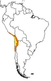
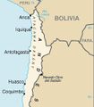
Map of Atacama Desert. The area most commonly defined as Atacama is yellow. In orange are the outlying arid areas of Sechura Desert, Altiplano, Puna de Atacama and Norte Chico.
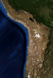
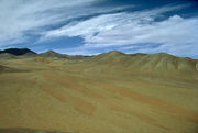
Atacama by NASA World Wind
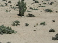
A chilla in Pan de Azúcar National Park in the coast of Atacama Desert
|
The Atacama Desert is a virtually rainless plateau in South America, covering a 600-mile (1,000 km) strip of land on the Pacific coast of South America, west of the Andes mountains. The Atacama desert is, according to NASA, National Geographic and many other publications, the driest desert in the world,[1][2][3] due to the rain shadow on the leeward side of the Chilean Coast Range, as well as a coastal inversion layer created by the cold offshore Humboldt Current.[4] The Atacama occupies 40,600 square miles (105,000 km2)[5] in northern Chile, composed mostly of salt basins (salares), sand, and felsic lava flows towards the Andes.
Contents |
Setting
The Atacama Desert ecoregion, as defined by the Worldwide Fund for Nature (WWF), extends from a few kilometers south of the Chile-Peru border to about 30° south latitude.[6] To the north lies the Sechura Desert ecoregion, in Peru, whilst to the south is the Chilean Matorral ecoregion. The National Geographic Society considers the coastal area of southern Peru to be part of the Atacama desert,[7][8] including the deserts south of the Ica Region.
To the east lies the less arid Central Andean dry puna ecoregion. The drier portion of this ecoregion is located south of the Loa River between the parallel Sierra Vicuña Mackenna and Cordillera Domeyko. To the north of the mentioned river lies the Pampa del Tamarugal.
The driest desert
Towards Atacama, near the deserted coast, you see a land without men, where there is not a bird, not a beast, nor a tree, nor any vegetation.
The Atacama is arguably the driest place on Earth,[10] and is virtually sterile because it is blocked from moisture on both sides by the Andes mountains and by the Chilean Coast Range. A coastal inversion layer created by the cold Humboldt Current and the anticyclone of the Pacific is essential to keeping the climate of the Atacama dry. The average rainfall in the Chilean region of Antofagasta is just 1 millimetre (0.04 in) per year. Some weather stations in the Atacama have never received rain. Evidence suggests that the Atacama may not have had any significant rainfall from 1570 to 1971.[5] It is so arid that mountains that reach as high as 6,885 metres (22,589 ft) are completely free of glaciers and, in the southern part from 25°S to 27°S, may have been glacier-free throughout the Quaternary, though permafrost extends down to an altitude of 4,400 metres (14,400 ft) and is continuous above 5,600 metres (18,400 ft). Studies by a group of British scientists have suggested that some river beds have been dry for 120,000 years.[11]
Some locations in the Atacama do receive a marine fog known locally as the Camanchaca, providing sufficient moisture for hypolithic algae, lichens and even some cacti. But in the region that is in the "fog shadow" of the high coastal crest-line, which averages 3,000 metres (10,000 ft) height for about 100 kilometres (60 mi) south of Antofagasta, the soil has been compared to that of Mars. Due to its otherworldly appearance, the Atacama has been used as a location for filming Mars scenes, most notably in the television series Space Odyssey: Voyage to the Planets.
In 2003, a team of researchers published a report in Science magazine titled "Mars-like Soils in the Atacama Desert, Chile, and the Dry Limit of Microbial Life" in which they duplicated the tests used by the Viking 1 and Viking 2 Mars landers to detect life, and were unable to detect any signs in Atacama Desert soil.[12] The region may be unique on Earth in this regard and is being used by NASA to test instruments for future Mars missions. The team duplicated the Viking tests in Mars-like Earth environments and found that they missed present signs of life in soil samples from Antarctic dry valleys, the Atacama Desert of Chile and Peru, and other locales.
In 2008, the Phoenix Mars Lander detected perchlorates on the surface of Mars at the same site where water was first discovered.[13] Perchlorates are also found in the Atacama and associated nitrate deposits have contained organics, leading to speculation that signs of life on Mars are not incompatible with perchlorates. The Atacama is also a testing site for the NASA funded Earth-Mars Cave Detection Program.[14]
Human occupation
The Atacama is sparsely populated, with most cities located along the Pacific coast.[15] In interior areas, oases and some valleys have been populated for millennia, being the seat of the most advanced Pre-Columbian societies found in Chile. These oases have had little population growth and urban development, and have, since the 20th century, faced conflicts over water resources that are needed for the coastal cities and the mining industry.
The coastal cities originated in the 16th, 17th, and 18th centuries during the time of the Spanish Empire, when they emerged as shipping ports for silver produced in Potosí and other mines. During the 19th century the desert came under control of Bolivia, Chile, and Peru, and soon became a zone of conflict due to unclear borders and the discovery of sodium nitrate deposits. After the War of the Pacific, in which Chile annexed most of the desert, cities along the coast developed into international ports, and many Chilean workers migrated there. With the guano and saltpeter booms of the 19th century the population grew immensely, mostly due to immigration from central Chile. In the 20th century the nitrate industry declined and at the same time the largely male population of the desert became increasingly problematic for the Chilean state. Anarchist and Communist ideas gained currency among the mine workers, and protest spread throughout the region.
In an oasis, in the middle of the desert, at about 2,000 metres (7,000 ft) elevation, lies the village of San Pedro de Atacama.
Its church was built by the Spanish in 1577. In pre-Hispanic times, before the Inca empire, the extremely arid interior was inhabited mainly by the Atacameño tribe. The tribe is noted for the construction of fortified towns called pucarás, one of which can be seen a few kilometers from San Pedro de Atacama.
The Atacama desert again became a source of wealth from the 1950s onwards due to copper mining. The Escondida and Chuquicamata porphyry copper mines are located within the Atacama Desert.
The Pan-American Highway runs through the Atacama in a north-south trajectory.
Abandoned nitrate mining towns
The desert has rich deposits of copper and other minerals, and the world's largest natural supply of sodium nitrate, which was mined on a large scale until the early 1940s. The Atacama border dispute over these resources between Chile and Bolivia began in the 1800s.
Now the desert is littered with approximately 170 abandoned nitrate (or "saltpeter") mining towns, almost all of which were shut down decades after the invention of synthetic nitrate in Germany at the turn of the 20th century (see Haber process). The towns include Chacabuco, Humberstone, Santa Laura, Pedro de Valdivia, Puelma and Maria Elena and Oficina Anita.
Trapped Miners
Main article: 2010 Copiapó mining accident
On August 5, 2010 33 Chilean miners ranging in ages from 19 to 63 became trapped 2,300 feet below the ground surface in a copper and gold mine located in the Atacama Desert. The trapped miners gained contact with the outside world 17 days after the mine collapse through a 3-inch diameter hole that was drilled to reach the trapped miners. Through this hole, the trapped miners have received food and other supplies. A video message released to the public on August 26, 2010 showed the miners living conditions 2,300 feet below the ground surface. It is estimated that the miners will not be reached until December 2010.
Astronomical observatories
Because of its high altitude, nearly non-existent cloud cover, dry air, and lack of light pollution and radio interference from the very widely spaced cities, the desert is one of the best places in the world to conduct astronomical observations. The European Southern Observatory operates two major observatories in the Atacama:
- The La Silla Observatory
- The Paranal Observatory, which includes the Very Large Telescope
A new radio astronomy telescope called ALMA, is being built by Europe, Japan, United States, Canada and Chile in the Llano de Chajnantor Observatory. A number of radio astronomy projects are currently operating in the Chajnantor area since 1999. For example: CBI, ASTE, ACT, among others.
 Map of the Atacama Desert (Chilean area) from the CIA World Factbook |
 Atacama Desert |
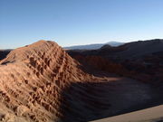 Scene from Valle de la Luna (Moon Valley) near San Pedro de Atacama |
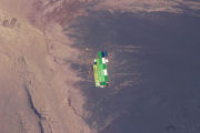 Solar Evaporation Ponds in the Atacama Desert |
Protected areas
- Pan de Azúcar National Park
- Pampa del Tamarugal National Reserve
- La Chimba National Reserve
Legends
- Alicanto
- Atacama Giant
See also
- Norte Grande, Chile
- Atacama Crossing
- Atacama border dispute
- Salar de Atacama
- List of deserts by area
- Mano del Desierto
- Llano de Chajnantor Observatory
References
Bibliography
- Braudel, Fernand, The Perspective of the World, ISBN 0-520-08116-1, vol. III of Civilization and Capitalism 1984 (originally published in French, 1979).
- Sagaris, Lake. Bone and dream : into the world's driest desert. 1st ed. – Toronto : A.A. Knopf Canada, c2000. ISBN 0-676-97223-3
Notes
- ↑ http://ngm.nationalgeographic.com/ngm/0308/feature3/
- ↑ http://www.extremescience.com/DriestPlace.htm
- ↑ http://quest.nasa.gov/challenges/marsanalog/egypt/AtacamaAdAstra.pdf
- ↑ Jonathan Amos (8 December 2005). "Chile desert's super-dry history". BBC News. http://news.bbc.co.uk/1/hi/sci/tech/4437153.stm. Retrieved 29 December 2009.
- ↑ 5.0 5.1 Wright, John W. (ed.); Editors and reporters of The New York Times (2006). The New York Times Almanac (2007 ed.). New York, New York: Penguin Books. pp. 456. ISBN 0-14-303820-6.
- ↑ and the most beautiful. "Terrestrial Ecoregions – Atacama desert (NT1303)". www.worldwildlife.org. http://www.worldwildlife.org/wildworld/profiles/terrestrial/nt/nt1303_full.html. Retrieved 11 March 2008.
- ↑ Viking Mission May Have Missed Mars Life, Study Finds
- ↑ Giant Penguins Once Roamed Peru Desert, Fossils Show
- ↑ quoted Braudel, Fernand, The Perspective of the World, ISBN 0-520-08116-1, vol. III of Civilization and Capitalism 1984 (originally published in French, 1979). p 388
- ↑ Boehm, Richard G.; Editors and writers of The World and Its People (2006). The World and Its People (2005 ed.). Columbus, Ohio: Glencoe. pp. 276. ISBN 0-07-860977-1.
- ↑ "Chile desert's super-dry history". BBC News. 8 December 2005. http://news.bbc.co.uk/1/hi/sci/tech/4437153.stm. Retrieved 25 April 2010.
- ↑ Mars-Like Soils in the Atacama Desert, Chile, and the Dry Limit of Microbial Life Science 7 November 2003: Vol. 302. no. 5647, pp. 1018–1021
- ↑ Thompson, Andrea. Scientists Set Record Straight on Martian Salt Find. http://www.space.com/scienceastronomy/080805-phoenix-perchlorate-update.html. Retrieved 6 August 2008
- ↑ Earth-Mars Cave Detection Program
- ↑ South America physical map
External links
- SanPedrodeAtacama.Net & Org
- News article on "Mars-like Soils in the Atacama Desert, Chile, and the Dry Limit of Microbial Life"
- National Geographic feature about Atacama
- Autonomous Robot Finds Life in Atacama Desert
- Atacama's Super-Dry History
|
|||||||||||||||||||||||||||||